Frozen precipitation accumulating on a surface creates a snow cover. Snow is an important and dominant feature of northern environments with cover present for more than 6 months of the year over large areas of the northern hemisphere. Its extent, dynamics, and properties (e.g., depth, density, water equivalent, grain size, and changes in structure throughout its vertical profile) affect climate (e.g., ground thermal regime), human activities (e.g., transportation, resource extraction, water supply, use of land, and ecosystem services), as well as infrastructure, hydrological processes, permafrost, extreme events (including hazards such as avalanches and floods), biodiversity, and ecosystem processes (Callaghan et al., 2011; DeBeer et al., 2016).
Snow Distribution in Canada
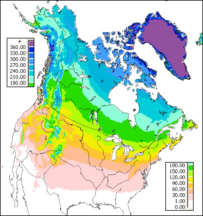
ground over snow seasons 1998/99 to 2014/15 from the
IMS-24 km daily snow cover product (Brown and Brasnett,
2010) updated annually. Click figure for larger image.
The levels of precipitation and prolonged below-freezing temperatures necessary for snow to accumulate occur for various periods of time during winter over most of Canada. Figure 1 shows the mean annual number of days with snow cover from the NOAA IMS-24 km daily snow cover product (Helfrich et al., 2007) over snow seasons from 1998/99 to 2014/15. The average annual duration of snow cover in Canada ranges from a minimum of less than 1 day per year on Queen Charlotte Islands off the B.C. coast to perennial snow cover over the ice caps of the Canadian Arctic Archipelago. According to the satellite data used to generate Figure 1, on average ~65% of Canadian land area is snow covered for more than half the year, which means that snow cover is the dominant land cover in Canada. How much snow accumulates on the ground is first determined by factors influencing snowfall such as latitude, elevation, and proximity to storm tracks and moisture sources. Once on the ground the terrain and land cover characteristics, as well as interactions with surface wind, take over to determine how much snow accumulates at a particular location. Local site characteristics also play a major role in snow melt processes in the spring.
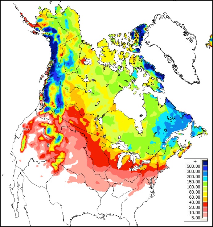
equivalent (mm) over the snow seasons 1998/99 to 2014/15
estimated from the Canadian Meteorological Centre daily
snow depth analysis dataset (Brown and Brasnett, 2010)
Click figure for larger image.
Figure 2 provides an estimate of the variation in annual maximum winter accumulation across Canada expressed as the depth of water (snow water equivalent or SWE) if the snow were melted. The largest accumulations are found in coastal mountain regions (e.g. B.C., Quebec-Labrador, and Eastern Canadian Arctic) which have large annual snowfall totals. The large amount of snowfall is related to proximity to storm tracks and moisture sources as well as orographic influences on precipitation and temperature. Snow accumulations are generally low over the continental interior where winters are cold and dry. The noticeably low SWE values over the western Canadian Prairie region are a result of the combination of low winter precipitation, winter melt events from Chinook winds and loss of snow from blowing snow sublimation. Snow cover over southern regions of Canada exhibits strong variability in response to the passage of winter storms. Current and historical Prairie SWE maps can be found on the SWE page.
The following figures display the current geographical average annual snowfall (Figure 3) and average maximum snow depth (Figure 4) in Canada. The deeper colours represent higher quantities.
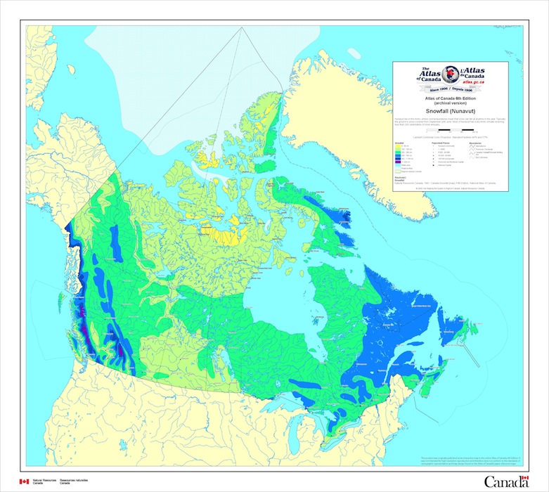
Figure 3
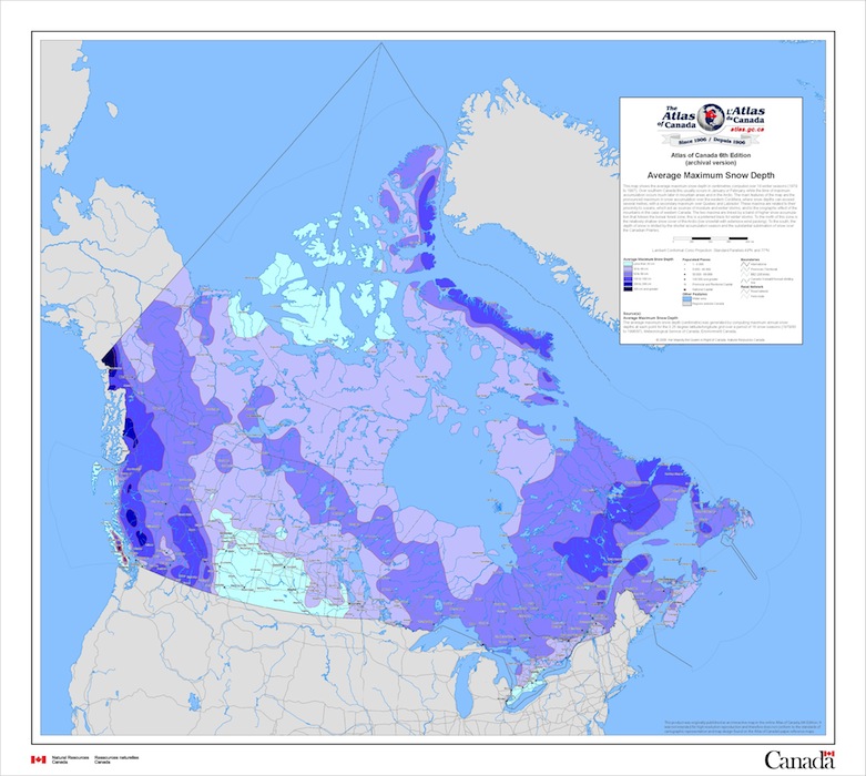
Figure 4
Click figure for larger image (Natural Resources Canada, 2009)
Factors Influencing Snow Distribution
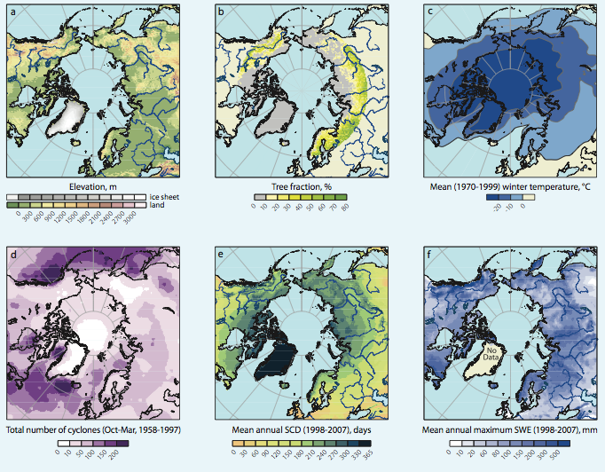
(b) tree fraction, (c) mean winter temperature, (d) number of
cyclones(stormy weather from low pressure system), (e)
mean annual snow-cover duration and (f) mean
annual maximum snow-water equivalent (SWIPA, 2011).
Click figure for larger image.
Snow cover extent throughout the Arctic is a function of elevation, vegetation, mean temperature, cyclonic activity, duration of snow cover and snow-water equivalent properties (Figure 5). Additionally, the global wind circulation influences snow cover location. The jet stream moves in a west to east direction, circulating systems through the cold continental interior towards the east. This relatively cold continental interior passage results in a higher snow cover in the eastern regions on continents across the Arctic. Additionally, vegetation cover and land topography influence snow cover characteristics. In areas with little vegetation, north of the treeline, snow cover is dense and remains for longer periods of time. In tundra regions, with sparse tall vegetation, and a diverse landscape, the snow cover is highly variable in both density and extent. In boreal forest regions, higher temperatures and vegetation magnitude allow snow to settle seasonally, with a more constant density and coverage (Figure 6). The snow-water equivalence of a region is influenced by the availability of moisture. This moisture is transported into the Arctic by cyclonic activity. This complex relationship generally denotes higher cyclonic activity, generates more moisture and consequentially higher local snow-water equivalent. Moreover, elevation differences affect the amount of moisture able to infiltrate specific regions. Areas obstructed by mountains (western North America) acquire less moisture than flat-lying areas (western Eurasia). Overall, lower tree fraction, lower temperatures and higher cyclonic activity permit longer snow-cover duration and higher snow-water equivalence (SWIPA, 2011).
References
Snow Links
Material on this page was provided by Ross Brown, Cryosphere Scientist, Environment Canada, Maren Pauly and Tristan Mills, Department of Geography, University of Waterloo.